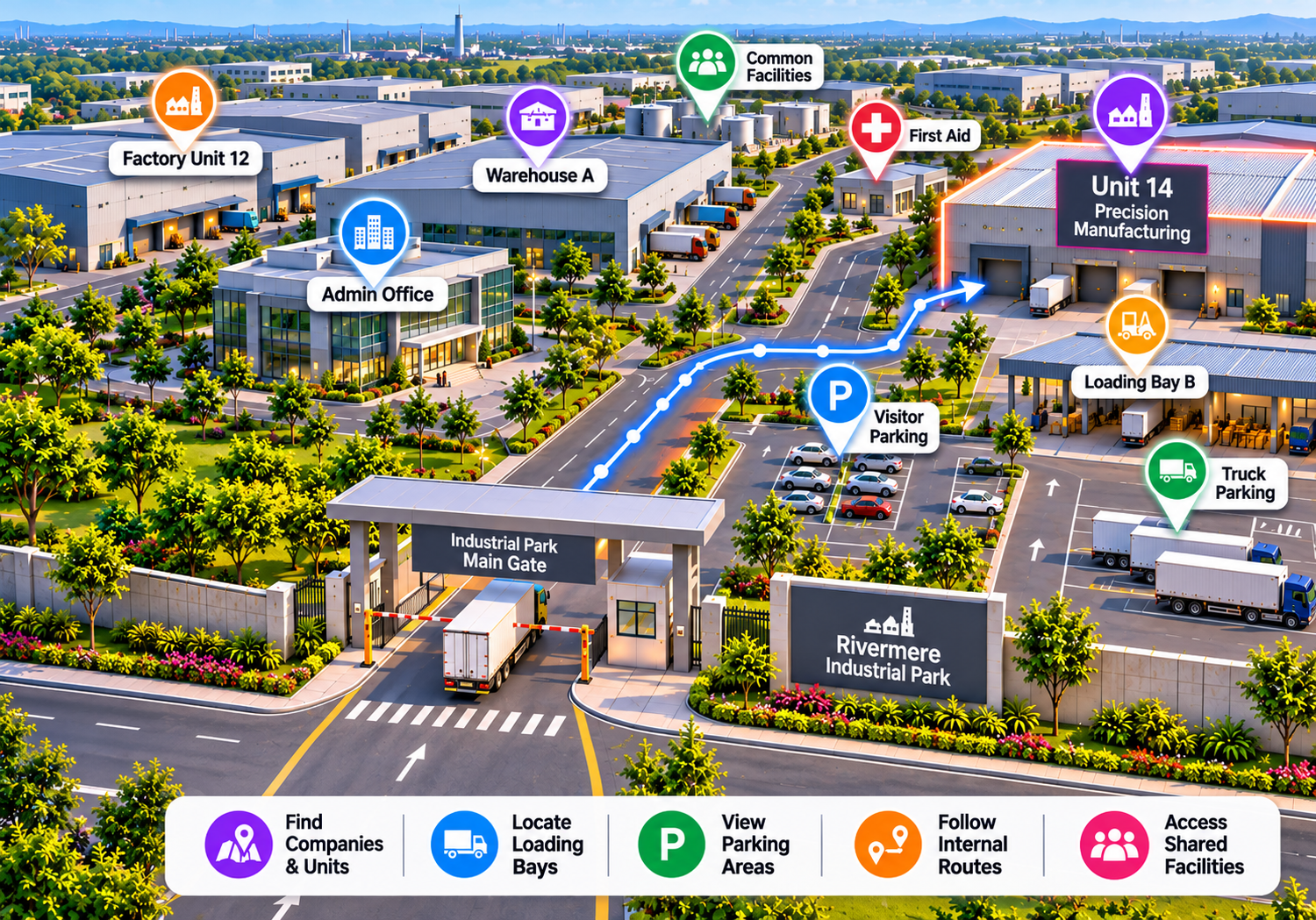
Interactive Maps for Industrial Parks: Simplify Site Navigation
Discover how interactive industrial park maps help employees, visitors, contractors, and delivery teams locate buildings, warehouses, production facilities, loading zones, and essential site services.
Arriving at a large industrial park, manufacturing complex, or logistics hub should be the start of an efficient business interaction. However, for many visitors, delivery drivers, contractors, and service providers, entering a multi-acre industrial estate brings immediate spatial confusion. Navigating sprawling industrial zones featuring complex internal road networks, similar-looking factory buildings, separate freight gates, and multiple warehouse loading bays frequently leads to delayed shipments, missed appointments, and heavy vehicle traffic congestion.
Truck drivers, maintenance contractors, equipment technicians, logistics coordinators, and clients routinely enter industrial properties with only a building number or company name. Without clear spatial guidance, identifying the correct entrance gate, finding designated loading docks, or locating administrative offices can turn a routine pickup or service visit into a stressful search.
Implementing interactive maps for industrial parks offers a practical, modern approach to site navigation. By digitizing industrial site plans and making interactive maps accessible on mobile devices and desktop web browsers, industrial park developers, facility managers, and estate operators can organize location data, streamline logistics access, and deliver a smooth navigation experience across complex commercial properties.
What Is an Interactive Map for an Industrial Park?
An interactive industrial park map is a digital, web-responsive visual representation of an industrial site that displays factory buildings, warehouses, manufacturing units, loading bays, internal roads, entrance gates, and shared infrastructure in an organized digital format.
Unlike static metal site boards at entrance gates or paper blueprints, digital industrial maps allow users to view the entire property overview, zoom into specific factory sectors, search for tenant companies, and tap points of interest (POIs) to review location details, such as loading dock guidelines, security gate protocols, or administrative contact links.
A Real-World Example
Consider a freight truck driver arriving at a 200-acre industrial estate to deliver raw materials to "Unit 14 - Precision Manufacturing." Instead of driving a heavy vehicle down narrow internal roads or stopping at security gates to ask for directions, the driver opens the industrial park's digital map on their smartphone or scans a QR code at the main entry gate. They search for "Precision Manufacturing" or select "Loading Zone B," immediately viewing the exact building location, designated truck access routes, and specific unloading bay doors without causing traffic bottlenecks.
Why Industrial Parks Need Better Site Navigation
Managing spatial navigation across expanding industrial developments presents unique operational and logistical challenges:
-
Sprawling Geographical Areas & Complex Road Networks: Industrial estates often cover vast land areas with intricate internal streets, turning loops, and perimeter access roads.
-
Similar-Looking Industrial Structures: Factory buildings, steel warehouses, and logistics sheds frequently share uniform architectural designs, making visual identification difficult from a distance.
-
Multiple Vehicle Access Points & Security Gates: Industrial complexes usually designate separate gates for heavy freight trucks, visitor cars, employee traffic, and pedestrian access.
-
Complex Loading & Unloading Zones: Facilities often feature multiple loading docks, outdoor staging areas, and freight bays that require precise identification.
-
High Volume of Temporary Contractors & Drivers: Delivery couriers, maintenance engineers, and freight drivers visit industrial sites daily without prior knowledge of the layout.
-
Remote Destination Sharing: Facility managers and tenant companies struggle to communicate exact building locations and loading bay instructions to external drivers over the phone.
Providing clear, accessible location data helps eliminate spatial uncertainty, ensuring safer, faster, and more efficient site navigation.
Key Benefits of Interactive Maps for Industrial Parks
Adopting digital wayfinding solutions for industrial facilities delivers practical advantages across property management, logistics, and site operations:
1. Help Visitors Find Factories and Buildings
Organized building listings and clearly labeled factory units mapped to visual site plans allow visitors, clients, and service providers to identify specific destinations instantly without guessing.
2. Make Warehouse Locations Easier to Identify
Mapping warehouse blocks, cold-storage facilities, and distribution centers helps logistics coordinators, inventory teams, and freight drivers locate specific storage units quickly.
3. Simplify Loading and Unloading Area Discovery
Clearly marking designated loading bays, truck staging areas, and freight doors ensures delivery personnel navigate directly to the correct unloading area, reducing unnecessary site transit.
4. Improve Understanding of Internal Roads and Entrances
Displaying internal roads, weight-restricted bridges, turning circles, entry gates, and exit points gives drivers an immediate spatial overview of the property's driving layout.
5. Support Employee and Contractor Navigation
Onboarding new factory staff, field contractors, maintenance crews, and equipment technicians becomes simpler when team members have self-service access to detailed facility maps.
6. Make Shared Facilities Easier to Locate
Industrial park maps can highlight shared site infrastructure, including:
-
Central administrative offices
-
Security checkpoints and weighbridges
-
Cafeterias and dining halls
-
Restrooms and locker facilities
-
Visitor parking lots and staging areas
-
Maintenance sheds and utility hubs
7. Improve Visitor Information Sharing
Property managers can establish a centralized digital site map accessible via web links or QR codes, ensuring consistent, up-to-date spatial information across all official estate channels.
8. Help Organize Large Industrial Properties
A structured digital map provides estate developers and facility managers with a visual framework to categorize multi-building complexes, present tenant directories, and manage property assets efficiently.
What Should an Industrial Park Map Include?
Industrial estate administrators should compile a comprehensive list of location markers and details when setting up an interactive site map:
-
Industrial Park Name & Master Layout: Clear visual graphics representing overall site boundaries, internal roadways, and sector blocks.
-
Factories & Manufacturing Units: Searchable labels for individual factory blocks, production plants, and processing facilities.
-
Warehouses & Distribution Centers: Outlined storage structures, logistics bays, and fulfillment centers.
-
Loading & Unloading Zones: Clearly marked freight doors, staging bays, weighbridges, and container yards.
-
Administrative & Security Offices: On-site management counters, main security booths, visitor check-in desks, and customs offices.
-
Entrances, Exits & Transit Hubs: Heavy vehicle gates, passenger car entrances, pedestrian turnstiles, and bus stops.
-
Parking Areas: Distinct markers for visitor parking, heavy truck staging lots, employee parking, and EV charging stations.
-
Shared Amenities: Cafeterias, restrooms, meeting rooms, and maintenance workshops.
-
Emergency Assembly Points: Verified safety zones, first-aid posts, and emergency assembly areas approved by site management.
Industrial Security Note: Property managers must balance helpful navigation with operational security. Avoid publicly displaying restricted production areas, private security camera positions, high-voltage utility grids, or confidential tenant storage details on public web maps.
Interactive Industrial Maps vs. Traditional Site Maps
While static metal entrance boards and printed paper site plans provide basic physical landmarks, digital interactive maps offer significant functional and operational advantages:
| Feature | Traditional Site Map (Print/Board) | Interactive Digital Map |
| Viewing the Layout | Fixed 2D overview panel at entrance gates | Interactive visual layout viewable on mobile screens |
| Finding Factory Buildings | Relies on small printed text and static grids | Searchable building markers with category filters |
| Locating Warehouses | Limited to static text labels on a board | Categorized overlays for storage and logistics blocks |
| Identifying Loading Zones | Basic static symbols on printed sheets | Highlighted freight bay markers easily found on mobile |
| Updating Information | Requires physical reprinting and sign replacement | Digital map content can be updated online instantly |
| Sharing with Visitors | Requires physical handouts or gate boards | Shareable via website URLs, web links, and QR codes |
| Accessing Location Details | Restricted to concise text on physical signs | Rich pop-up profiles with bay rules, hours, and contact links |
How to Create an Interactive Industrial Park Map
Building an interactive map for a manufacturing estate or logistics hub follows a practical, structured process:
Step 1: Collect an Accurate Industrial Site Plan
Gather an up-to-date vector site plan, CAD drawing, or high-resolution architectural layout showing building footprints, internal roads, gates, loading areas, and parking zones.
Step 2: Identify Important Industrial Locations
Compile a complete list of factory units, warehouses, administrative offices, loading docks, security gates, and shared amenities.
Step 3: Organize Buildings and Facilities
Group similar site locations into intuitive categories (e.g., Manufacturing, Warehousing, Logistics & Loading, Administration, Parking & Gates).
Step 4: Choose Suitable Mapping Software
Select a web-first mapping platform that supports your site graphics, mobile display goals, custom marker placements, and publishing requirements.
Step 5: Add Location Markers and Details
Plot pins, upload building details, add tenant company names, and customize marker colors to align with estate branding.
Step 6: Review Access and Location Information
Verify internal roads, heavy vehicle gates, loading bays, and parking zones on-site. Ensure sensitive operational areas remain restricted from public views.
Step 7: Test the Interactive Map
Test the map across mobile smartphones, tablets, and desktop browsers to verify label legibility, category search responsiveness, touch controls, and marker accuracy.
Step 8: Publish and Share the Map
Deploy the map by embedding it on the industrial park's website, sending direct links in delivery confirmation portals, and displaying QR codes on entrance gate signage.
Step 9: Maintain and Update Site Information
Establish an operational schedule to review and update map details whenever tenant companies move, loading bays are reconfigured, or internal road access changes.
How Industrial Facility Managers Can Use Digital Maps
Digital mapping solutions serve as versatile operational tools for industrial property management teams:
-
Guiding Delivery Drivers to Loading Bays: Direct freight trucks to specific unloading doors and staging lots, reducing heavy vehicle traffic congestion.
-
Orienting Contractors & Service Engineers: Help external technicians locate specific factory units, utility offices, and maintenance sheds quickly.
-
Organizing Multi-Tenant Estates: Maintain a centralized, searchable digital directory accessible to all park tenants and visitors.
-
Communicating Gate Access Rules: Highlight passenger car gates versus heavy freight entrances to maintain site traffic discipline.
-
Presenting Sites to Prospective Tenants: Showcasing available factory units, warehouses, and infrastructure on an interactive map aids commercial real estate leasing.
Note: Digital maps complement—rather than replace—official site security checks, physical road signage, and mandatory occupational safety instructions.
Best Practices for Designing an Effective Industrial Park Map
To ensure a digital industrial map delivers maximum utility, property managers should follow these core design recommendations:
-
Use Consistent Building Identifiers: Ensure digital building numbers and unit codes match physical factory door signage exactly.
-
Organize Categories Intuitively: Group locations logically so users can filter by Manufacturing, Logistics, Offices, or Parking effortlessly.
-
Design for Mobile Screen Readability: Choose high-contrast color schemes, legible typography, and touch-friendly interface buttons suitable for outdoor smartphone viewing.
-
Clearly Identify Access Points: Distinguish freight truck entrances, passenger vehicle gates, and pedestrian walkways clearly.
-
Keep Layouts Uncluttered: Avoid overcrowding the visual map screen with unnecessary architectural detail that obscures internal roads or building markers.
-
Protect Confidential Site Data: Never publish private tenant storage inventories, security camera locations, or restricted access passcodes.
-
Verify Safety-Related Markers: Ensure emergency assembly points, security booths, and first-aid stations are verified before publishing.
-
Establish an Update Workflow: Assign operational responsibility to a specific team member to publish map updates as leasing or layout changes occur.
Common Mistakes to Avoid When Creating Industrial Maps
When setting up a digital site map, avoid these common implementation pitfalls:
-
Publishing Outdated Site Plans: Using old site layouts that fail to show new warehouse additions or reconfigured internal roads misleads drivers.
-
Inconsistent Building Names: Labeling a structure "Building 4" on the map while physical signage reads "Unit D" creates confusion.
-
Omitting Loading Bay Details: Marking a warehouse footprint without showing where freight trucks should actually unload causes traffic delays.
-
Neglecting Mobile Usability: Failing to test map load times and touch controls on mobile browsers leads to poor experiences for drivers on-site.
-
Exposing Restricted Data: Including private tenant operational data or restricted security details compromises facility safety.
-
Failing to Maintain Content: Leaving tenant listings or contact details unupdated after factory relocations damages trust in the digital map.
How to Choose Industrial Park Mapping Software
Industrial park operators, developers, and facility managers evaluating digital mapping software should compare platforms against key operational criteria:
-
Mobile Web Performance: The platform must load fast and run smoothly in mobile web browsers across iOS and Android without forcing users to install a native app.
-
Ease of Content Management: Look for an intuitive management dashboard that lets non-technical staff add building pins, edit tenant details, and update categories easily.
-
Search & Category Capabilities: Robust search tools capable of matching unit numbers, company titles, and facility categories (e.g., "Warehouse" or "Gate 2").
-
Customization & Branding: Options to apply custom brand colors, custom map markers, fonts, and property logos.
-
Embedding & Sharing Flexibility: Simple options to embed interactive maps into estate websites, logistics portals, and generate shareable web links or QR codes.
-
Platform Reliability & Support: Cloud infrastructure capable of handling traffic spikes, backed by clear documentation and responsive customer support.
How eMap.live Fits Into an Industrial Mapping Workflow
For industrial park developers, facility managers, and estate operators seeking an efficient way to build and share digital property site plans, eMap.live provides a flexible, web-based interactive mapping platform.
By visiting https://emap.live/, site administrators can review how the platform supports commercial real estate and industrial property mapping use cases. Confirmed platform capabilities relevant to industrial parks include:
-
Custom Vector Map Building: Transform architectural site drawings or vector floor plans into clean, mobile-friendly interactive maps featuring clickable building markers and loading bay pins.
-
App-Free Mobile Access: Maps run directly inside standard mobile web browsers on iOS and Android devices, allowing drivers and visitors to view site layouts instantly without downloading native apps.
-
Searchable Directories & Categories: Organize industrial locations into custom searchable categories (e.g., Factories, Warehouses, Loading Bays, Parking, Gate Access), making destinations easy to find.
-
QR Code & Web Link Sharing: Easily generate shareable web links and QR codes to display on physical security gate signage, delivery portals, or estate websites.
-
Simple Dashboard Management: Update unit labels, edit tenant descriptions, or adjust facility pins quickly through an intuitive web management dashboard without coding skills.
Site administrators should visit eMap.live to inspect current platform features, supported graphic formats, and documentation to determine how it fits their industrial site mapping workflow.
Frequently Asked Questions
1. What is an interactive map for an industrial park?
An interactive map for an industrial park is a digital, mobile-responsive visual guide that displays factory units, warehouses, loading zones, internal roads, and site amenities. Accessible via web browsers, it helps visitors and delivery drivers navigate industrial properties easily.
2. How do interactive maps improve industrial park navigation?
Digital maps provide searchable location databases and clear visual markers directly on mobile devices. Drivers and contractors can locate specific factory units, find designated loading bays, and identify correct entrance gates without getting lost.
3. What information should an industrial park map include?
An industrial park map should include factory buildings, manufacturing units, warehouses, loading bays, internal roads, vehicle entrance gates, security posts, parking areas, cafeterias, and emergency assembly points.
4. Can interactive maps show multiple factories and warehouses?
Yes. Digital mapping platforms allow administrators to plot and label multiple factory blocks, logistics sheds, and storage facilities across large site layouts, making specific units easy to search and identify on-screen.
5. How can visitors find buildings in large industrial parks?
Visitors can open the industrial park's digital map on their smartphone, filter by categories (e.g., Factories, Warehousing, Offices), or search for specific company names to view exact visual locations across the estate.
6. Can industrial maps display loading and unloading areas?
Yes. Digital maps can highlight designated freight loading bays, container yards, and truck staging lots to direct heavy vehicle drivers to their exact delivery destinations.
7. How can facility managers create an interactive industrial site map?
Facility managers can create a map by collecting a site layout, compiling location details, categorizing buildings, uploading graphics to an interactive map platform like eMap.live, adding pins and descriptions, testing mobile performance, and sharing via QR codes or links.
8. Can QR codes be used to share industrial park maps?
Yes. Property managers can generate QR codes linked directly to their interactive map URL. Placing these QR codes on security gate signboards, entrance kiosks, or delivery passes allows drivers to launch the map instantly on their phones.
9. What are the benefits of digital maps for manufacturing facilities?
Digital maps improve location discovery for external service technicians, simplify delivery routing for logistics teams, organize shared site infrastructure, and enhance overall site management.
10. What should businesses consider when choosing industrial mapping software?
Businesses should evaluate software based on mobile web performance, ease of content updates, custom branding flexibility, category search capabilities, QR code support, cloud reliability, and transparent pricing.
11. Can interactive maps replace industrial safety signage?
No. Digital maps complement—rather than replace—required physical safety signage, mandatory security checkpoint procedures, site speed limit posts, and official emergency instructions.
Conclusion: Make Industrial Sites Easier to Navigate
Providing clear, accessible spatial guidance is an essential component of modern industrial estate management. As manufacturing parks and logistics hubs grow larger, static paper maps and entrance billboards alone are no longer sufficient to guide delivery drivers, contractors, and visitors effectively.
Interactive maps for industrial parks bridge the gap between physical property architecture and digital self-service convenience. By organizing factory layouts, publishing searchable tenant directories, clarifying loading bay access, and providing mobile web access via QR codes, property managers can eliminate site navigation confusion and elevate operational efficiency across commercial industrial assets.
Ready to make your industrial site easier to navigate? Explore eMap.live to evaluate how its web-based interactive mapping platform can support your property's navigation strategy.
