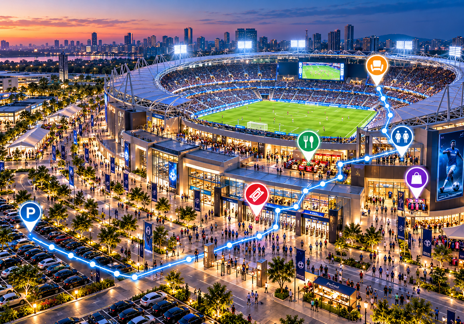
Interactive Maps for Sports Stadiums: Improve Fan Navigation
Discover how interactive stadium maps help fans find seats, entrances, concessions, restrooms, parking areas, and essential facilities for a smoother match-day experience.
Attending a live sporting event—whether a high-stakes football derby, an international cricket test, a marquee basketball game, or a major championship—is meant to be an exhilarating experience. However, for many supporters, arriving at a large sports venue brings unexpected spatial navigation hurdles. Finding the correct stadium gate, locating assigned seating blocks among tens of thousands of chairs, identifying parking zones, and finding restrooms or food concessions often turns an exciting day into a stressful journey.
Traditional paper guides and static overhead directional signs provide basic orientation, but they can easily be overlooked in dense crowds and cannot display rich, searchable location details.
Implementing interactive maps for sports stadiums offers a modern, mobile-friendly approach to visitor wayfinding. By digitizing venue layouts and making maps easily accessible on mobile devices, stadium operators, facility managers, and event organizers can help fans explore the venue with confidence, find essential facilities effortlessly, and enjoy a seamless match-day experience.
What Are Interactive Maps for Sports Stadiums?
An interactive stadium map is a digital visual representation of a sports venue that allows fans to explore stadium layouts, discover amenities, locate specific seating sections, and view spatial details directly on their smartphones, tablets, or desktop browsers.
Unlike static image diagrams or printed physical flyers, interactive digital maps allow users to zoom in on specific concourses, toggle between different stadium levels, search for locations by keyword or category, and tap points of interest (POIs) to view location profiles, such as opening times or menus.
To understand how digital maps enhance sports venue operations, it helps to compare them with traditional mapping methods:
-
Printed Stadium Flyers: Distributed at entry gates or information booths, paper maps are easily damaged or misplaced, costly to print repeatedly, contribute to waste, and cannot be updated during multi-day events.
-
Static PDF Maps: While viewable on mobile phones, static PDF files require frustrating pinching and zooming, offering no search functionality or interactive category filtering.
-
Physical Wall Signs & Directional Boards: Fixed signage offers essential physical landmarks upon arrival, but it cannot display comprehensive facility descriptions or adapt quickly when entry gates or food vendors change.
-
General-Purpose Navigation Apps: Standard public mapping services work well for driving directions to a stadium's main parking gate, but they lack internal concourse floor plans, specific seating stand layouts, gate-to-section maps, and custom venue branding.
Interactive map platforms bridge this gap by offering clean, property-specific digital maps designed explicitly for venue visitor navigation.
Why Stadiums Need Better Fan Navigation
Sprawling sports venues and multipurpose arenas present unique architectural and spatial navigation challenges that directly affect the overall fan experience:
-
Locating the Correct Entry Gate: Entering through the wrong gate at a multi-entrance stadium often results in long, unnecessary walks around perimeter concourses.
-
Finding Seating Sections, Blocks, and Rows: Finding assigned seats across multi-tiered stands, executive suites, or lower bowls can be confusing for first-time visitors.
-
Locating Restrooms and Food Concessions: Long queues at popular food outlets and restrooms make it hard for fans to quickly find alternative facilities on nearby concourses during halftime breaks.
-
Identifying Fan Zones and Merchandise Shops: Supporters searching for official team stores, sponsor activations, or pre-match fan zones often miss out due to a lack of clear visual direction.
-
Locating Accessible Entrances and Facilities: Mobility-impaired supporters, families with strollers, and elderly fans require clear identification of step-free pathways, accessible ramps, elevators, and companion restrooms.
-
Navigating Parking Lots and Drop-Off Zones: Identifying designated parking decks, rideshare pickup spots, bus bays, and public transit links after a match can be chaotic without clear spatial guidance.
Providing clear, accessible venue guidance helps reduce spatial confusion, allowing supporters to spend less time lost in concourses and more time enjoying the event.
Key Benefits of Interactive Stadium Maps
Adopting digital wayfinding solutions for sports venues provides tangible advantages for fans, venue operators, and event staff alike:
1. Easier Seat and Section Discovery
Clearly labeled digital maps help fans locate stadium stands, seating blocks, and relevant entry gates before they step into the concourse. Note that exact seat-level detail depends on the accuracy and depth of the published map dataset.
2. Faster Venue Orientation
Supporters can review interactive maps on their smartphones before arriving at the venue or while walking through entrance plazas, helping them familiarize themselves with the stadium layout.
3. Easier Access to Stadium Facilities
Digital maps enable visitors to locate restrooms, food courts, beverage counters, first-aid posts, merchandise outlets, and customer service desks using intuitive category filters.
4. Better Parking and Entrance Planning
By identifying designated parking zones, valet desks, rideshare drop-offs, and entry gates in advance, fans can plan their arrival route smoothly, reducing bottlenecks near main gates.
5. Improved Accessibility Information
Maps can highlight accessible entry gates, ramps, elevators, and companion facilities, helping mobility-impaired visitors plan an accessible route through the venue.
6. A More Convenient Fan Experience
Centralizing venue information into a clear digital format eliminates confusion, helping supporters navigate the venue confidently and make the most of their match-day experience.
What Should an Interactive Sports Stadium Map Include?
A comprehensive digital sports venue map should feature clear visual representations and searchable markers for all key visitor locations:
-
Stadium Entrances and Turnstile Gates: Distinct markers for public entry gates, VIP entrances, media entry points, and member gates.
-
Seating Stands, Blocks, and Sections: Outlined seating bowls, grandstands, family enclosures, and hospitality suites.
-
Accessible Facilities: Step-free entryways, ramps, elevators, accessible seating areas, and accessible restrooms.
-
Restrooms: Categorized indicators for men's, women's, gender-neutral, and accessible facilities.
-
Food Courts and Concessions: Outlets labeled by food type (e.g., quick bites, beverages, dietary-specific vendors).
-
Merchandise Stores: Official team outlets, pop-up merchandise stalls, and souvenir kiosks.
-
First-Aid and Safety Stations: Medical posts, security desks, and lost-and-found stations.
-
Fan Zones and Entertainment Areas: Pre-match entertainment zones, kid play areas, and sponsor display booths.
-
Parking and Transport Hubs: Parking decks, rideshare pickup spots, bus terminals, and nearby train or metro stations.
-
Emergency Exits: Venue-approved safety exit locations aligned with official stadium safety protocols.
How Interactive Maps Support Different Sports Venues
Different sports and facility types have unique spatial mapping requirements:
Football Stadiums
Multi-tiered football venues feature large perimeter concourses and thousands of seating blocks. Digital maps guide supporters to the exact stand entrance, nearest concession stand, and official team merchandise stores.
Cricket Grounds
Cricket venues often span large outdoor perimeters with separate historical pavilions, open grass banks, covered grandstands, and hospitality enclosures. Clearly labeled maps help spectators locate their stand gate, refreshment points, and member areas during long match days.
Basketball and Indoor Arenas
Multi-level indoor arenas combine tight concourses, vertical escalator banks, corporate suites, and bowl seating. Interactive maps simplify vertical navigation between concourse levels, food courts, and exit gates.
Multipurpose Sports Venues
Venues hosting rotating sports, concerts, and tournaments require adaptable mapping tools. Operators can publish updated layout views matching specific seating arrangements or event-specific fan zones.
Interactive Stadium Maps vs. Traditional Stadium Maps
While printed pocket guides and physical directional boards still serve as handy physical reference tools, digital interactive maps offer clear operational and functional advantages.
| Feature | Traditional Printed Map | Interactive Digital Map |
| Access | Requires collecting a physical copy on-site | Viewable instantly via web links or mobile devices |
| Location Discovery | Restricted to static graphics and small labels | Interactive markers, clickable details, and categories |
| Searching | Manual visual inspection of paper sheets | Keyword search by category, vendor, or gate label |
| Updating Information | Requires expensive reprinting and distribution | Updated instantly via a digital publishing dashboard |
| Mobile Convenience | Physical paper map to carry around | Responsive web view accessible on smartphones |
| Distribution | Physical handouts at gates or info booths | Shared via QR codes, websites, or event emails |
| Backup Capability | Works without mobile data or battery power | Requires an active mobile web connection |
How to Create an Interactive Map for a Sports Stadium
Creating an interactive stadium map follows a practical, step-by-step workflow:
-
Obtain an Accurate Stadium Layout: Secure an approved, high-resolution vector floor plan or master layout from venue management.
-
Identify Important Locations: Audit all entrance gates, seating blocks, concession stands, restrooms, fan zones, and parking areas.
-
Organize the Map into Categories: Group points of interest into intuitive categories (e.g., Gates, Seating, Food & Drink, Merchandise, Services).
-
Add Clear Labels and Descriptions: Use clear venue nomenclature matching the physical signage on stadium gates and concourses.
-
Choose a Suitable Mapping Platform: Select an interactive map software that offers custom branding, mobile responsiveness, and easy editing tools.
-
Test the Map: Verify map performance, search responsiveness, and visual clarity across mobile smartphones, tablets, and desktop displays.
-
Publish and Share the Map: Embed the map on the official stadium website, send links in pre-match emails, and deploy access points across the venue.
-
Keep Information Updated: Review and edit map markers whenever concession vendors change, gates are re-labeled, or temporary fan zones are added.
How QR Code Maps Can Improve Stadium Navigation
Deploying QR codes across physical venue touchpoints provides a fast way to deliver browser-based digital maps directly to supporters' mobile screens without forcing app downloads.
Stadium operators can place QR codes strategically across key venue locations:
-
Ticket turnstiles, main entrance gates, and perimeter fences
-
Information desks, customer service booths, and ticket offices
-
Parking garage elevators, shuttle stops, and rideshare pickup zones
-
Digital or printed match-day programs and fan guides
-
Concourse directional posts, pillar signage, and entry portal walls
-
Pre-match email confirmations and digital ticketing portals
When fans scan a QR code with their smartphone camera, the browser opens the interactive map instantly, allowing them to locate their gate or seat section in seconds.
How to Choose the Right Stadium Mapping Software
Stadium operators, venue administrators, and technology managers should evaluate digital mapping platforms against key operational criteria:
-
Ease of Creation and Maintenance: Look for an intuitive dashboard that allows non-technical venue staff to add markers, edit labels, and publish updates quickly.
-
Representation of Complex Layouts: Ensure the platform can cleanly handle multi-tier stands, sprawling concourses, and outdoor perimeter zones.
-
Category and Search Capabilities: Verify that users can search for destinations by gate name, stand title, or amenity category.
-
Mobile-Friendly Display: The software must load fast and run smoothly in standard mobile browsers across iOS and Android without mandatory native app downloads.
-
Customization and Branding: Ensure the platform supports custom brand colors, custom map pins, fonts, and stadium logos.
-
Sharing and Embedding Options: Simple options to embed interactive maps into stadium websites, digital signage displays, and fan portals.
-
QR-Code Support: Capability to generate and link QR codes directly to specific map views or full layout views.
-
Pricing, Scalability, and Reliability: Dependable cloud infrastructure capable of handling high visitor web traffic during peak match-day hours.
How eMap.live Can Help With Interactive Mapping
For sports venue operators and event planners seeking an efficient way to create and share digital property layouts, eMap.live offers a flexible interactive mapping platform.
eMap.live enables venue managers to convert stadium site plans into searchable, mobile-responsive digital maps. Confirmed platform capabilities relevant to sports venue mapping include:
-
Custom Interactive Map Building: Upload venue graphics and create interactive points of interest for entry gates, seating stands, concession outlets, and guest services.
-
Mobile Web Accessibility: Maps run directly in standard mobile web browsers on iOS and Android devices, ensuring seamless access for supporters without requiring app store downloads.
-
Searchable Locations & Categories: Organize stadium locations into custom categories, helping fans search for specific stands, gates, or amenity types.
-
QR-Code & Web Link Distribution: Generate shareable web links and QR codes easily for placement on physical signage, printed guides, or stadium websites.
-
Simple Content Management: Update gate labels, concession profiles, or facility locations quickly through an intuitive web management dashboard.
If you are evaluating digital mapping tools for your sports facility, explore eMap.live to see how its interactive mapping features align with your stadium's navigation goals.
Best Practices for Designing an Effective Stadium Map
To ensure a digital stadium map delivers maximum value to supporters, venue operators should follow these design and operational recommendations:
-
Keep the Visual Layout Clear: Avoid cluttering the map graphic with excessive visual detail that obscures walking routes or gate markers on small mobile screens.
-
Use Consistent, Familiar Labels: Label gates, stands, and sections using the exact names found on physical concourse signage and game tickets.
-
Highlight Essential Visitor Amenities: Ensure restrooms, first-aid posts, customer service desks, and water stations are easy to locate.
-
Design for High Mobile Readability: Choose high-contrast colors, legible fonts, and touch-friendly interface buttons suitable for outdoor lighting.
-
Provide Accessible Facility Information: Clearly mark accessible ramps, step-free pathways, elevators, and companion seating areas.
-
Test with First-Time Visitors: Walk the venue concourses while testing the digital map on a smartphone to verify marker placement accuracy.
-
Maintain Printed Alternatives: Keep physical overview maps available at info counters as secondary backups for fans without mobile devices.
-
Establish an Update Workflow: Assign operational responsibility for updating map details prior to every major tournament or match.
The Future of Digital Wayfinding in Sports Stadiums
Digital venue wayfinding continues to evolve alongside broader smart stadium technology trends:
-
App-Free Web Platforms: Growing preference for lightweight browser maps accessible via QR codes, eliminating app download barriers for casual match-day visitors.
-
Contextual QR Code Deployment: Placing location-specific QR codes across concourses (e.g., at Gate 4) that open maps pre-centered on the fan's immediate surroundings.
-
Connected Digital Signage: Interactive concourse touchscreen displays allowing fans to scan a QR code and transfer visual map directions directly to their smartphones.
-
Multilingual Map Profiles: Automated language translation within web map interfaces, helping international sports fans navigate venues in their preferred language.
By adopting accessible digital mapping platforms today, stadium operators lay a solid foundation for modern, stress-free fan experiences.
Conclusion
Providing clear, accessible venue navigation is an essential part of modern sports venue management. As stadiums grow more complex and fan expectations shift toward digital self-service solutions, traditional paper brochures and static wall signs alone are no longer sufficient.
Interactive maps for sports stadiums solve concourse navigation challenges, help fans discover facilities and seating stands, and reduce routine directional queries for venue staff. By choosing a mobile-friendly mapping platform, organizing intuitive location categories, and placing QR access points strategically across the venue, stadium operators can ensure supporters spend less time lost in concourses and more time cheering for their team.
Ready to make your venue's seating and facilities easier to explore? Discover how eMap.live can help you create custom, interactive digital maps tailored to your sports stadium or arena.
Frequently Asked Questions
1. What are interactive maps for sports stadiums?
Interactive maps for sports stadiums are mobile-responsive digital guides that help supporters explore and navigate sports venues. Accessible on smartphones or web browsers, they feature searchable gate locations, clickable facility profiles, category filters, and visual spatial guidance.
2. How do interactive stadium maps improve fan navigation?
Digital maps allow fans to locate entry gates, seating stands, food concessions, restrooms, and official merchandise outlets independently. By providing searchable location databases and visual layouts directly on mobile devices, digital maps eliminate concourse confusion.
3. What should a digital stadium map include?
A digital stadium map should include entry turnstile gates, seating stands and sections, accessible pathways, restrooms, food and beverage concessions, merchandise outlets, first-aid posts, customer service desks, fan zones, and parking areas.
4. Can fans use interactive stadium maps on their phones?
Yes. Modern interactive stadium maps are web-based and optimized for mobile browsers across iOS and Android devices, allowing fans to open maps instantly via web links or QR codes without downloading native applications.
5. How can stadium operators create an interactive map?
Stadium operators can create an interactive map by procuring an accurate stadium layout, categorizing key locations, uploading the graphics to an interactive map platform like eMap.live, adding markers and descriptions, customizing brand styling, and sharing the map via QR codes and web links.
6. Can QR codes be used for stadium maps?
Yes. Stadium operators can display QR codes at entry gates, ticket offices, parking structures, concourse pillars, and printed programs. Fans scan the QR code with their mobile phone camera to open the interactive map instantly in their mobile browser.
7. What is the difference between a stadium map and indoor navigation software?
A stadium map provides visual interactive layouts, searchable location markers, and category guidance accessible via web browsers. Indoor navigation typically refers to advanced hardware-assisted systems that offer real-time "blue-dot" position tracking using sensors like Bluetooth beacons.
8. How should stadium operators choose mapping software?
Stadium operators should evaluate software based on mobile browser performance, ease of content management, search capabilities, custom branding options, QR-code features, multi-tier layout support, platform reliability, and pricing alignment with operational needs.
