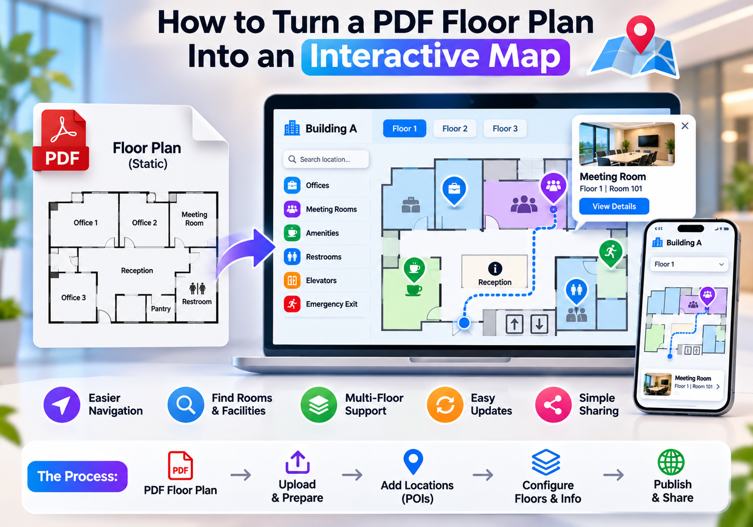
How to Turn a PDF Floor Plan Into an Interactive Map
Learn how to transform a static PDF floor plan into an interactive digital map with clickable locations, organized spaces, and useful location information for visitors and users.
Many architects, facility managers, property developers, and business owners rely on static PDF floor plans to store building layouts. While PDFs are excellent for printing architectural blueprints or sending static documents via email, they often fall short when used as navigation guides. Viewing a complex PDF blueprint on a smartphone or mobile device typically involves tedious pinching, zooming, and scrolling across dense, static graphics.
Visitors arriving at an office complex, shopping mall, hospital, or university campus frequently find it difficult to identify specific meeting rooms, department counters, or essential amenities from a static PDF document. Furthermore, printed PDF floor plans are expensive to re-distribute whenever tenant rosters change, building sections undergo renovations, or room designations shift.
Transforming static PDF floor plans into interactive digital maps solves these navigational and operational challenges. By converting building layouts into interactive web-based maps, property managers can add clickable location markers, organize room directories, and provide accessible spatial guidance directly on visitors' smartphones and desktop browsers. In this comprehensive guide, you will learn how to turn a PDF floor plan into an interactive map step-by-step, explore essential preparation requirements, and review best practices for digital map publishing.
What Is an Interactive Floor Plan?
An interactive floor plan is a digital, web-responsive visual representation of a building or facility layout that allows users to explore mapped spaces, select specific rooms or points of interest (POIs), filter categories, and access rich location details.
To understand the value of digital mapping, it helps to distinguish between three common format levels:
-
Static PDF Floor Plan: A fixed, non-interactive document or vector blueprint primarily intended for printing or static document viewing. It offers no interactive searching, category filtering, or dynamic data pop-ups.
-
Digital Floor Plan: A static image file (such as a PNG or JPEG) hosted on a web page or digital screen. While readable on digital screens, it lacks interactive elements or searchable data points.
-
Interactive Floor Plan: A dynamic visual interface where users can tap or click specific rooms, building wings, or amenity icons to view descriptive profiles, operating hours, contact links, or suite details.
A Practical Example
Imagine a guest attending a corporate workshop inside a multi-story office building. Instead of scrolling through an unformatted, multi-page architectural PDF on their phone, the visitor opens an interactive digital map via a web link or entrance QR code. They type "Conference Room B" into a search field or select "Meeting Spaces" from a menu, immediately highlighting the room's visual location on the third-floor layout alongside reception contact details and nearby elevator banks.
Why Convert a PDF Floor Plan Into an Interactive Map?
Converting static PDF architectural layouts into interactive digital maps provides immediate practical advantages for property managers and visitors alike:
-
Making Building Layouts Easier to Explore: Digital maps provide an intuitive interface where users can pan across floors and zoom into specific suites effortlessly.
-
Helping Visitors Identify Rooms & Facilities: Adding labeled markers allows users to pinpoint exact meeting rooms, department counters, and shared amenities in seconds.
-
Organizing Location Data: Interactive categories enable users to filter spatial points by type, such as Offices, Restrooms, Dining, or Emergency Exits.
-
Simplifying Information Sharing: Web-first interactive maps can be accessed instantly via web URLs, embedded iFrames, or camera-scanned QR codes without sending bulky file attachments.
-
Streamlining Maintenance & Updates: Operations teams can edit room labels, update tenant descriptions, or re-assign suite details digitally without re-printing or re-distributing paper floor plans.
Interactive digital floor plans serve as a powerful digital extension that complements physical building directories, wall signage, and front-desk reception staff.
Key Benefits of Turning PDF Floor Plans Into Interactive Maps
Transforming static blueprints into digital mapping experiences offers functional benefits across facility management and visitor communications:
1. Make Building Layouts Easier to Explore
Interactive digital maps deliver a user-friendly spatial overview, replacing dense architectural CAD grids with clean visual representations optimized for screen viewing.
2. Add Clickable Locations
Clickable location markers allow visitors to tap specific rooms, offices, or facilities to display pop-up profiles containing suite numbers, department descriptions, operating hours, and web links.
3. Improve Visitor Experience
Providing clear, searchable spatial information reduces anxiety for first-time visitors, job candidates, patients, and clients arriving for appointments.
4. Organize Multiple Locations & Floors
Multi-story buildings and multi-wing facilities can be organized into structured visual layers, allowing users to toggle between different floors or outdoor grounds cleanly.
5. Make Location Data Easy to Share
Digital mapping platforms generate web URLs and embed codes, enabling property managers to publish maps directly on company websites, visitor portals, or digital signage.
6. Simplify Map Updates
When a tenant relocates or a department shifts offices, property administrators can update digital map data centrally without re-issuing static PDF documents or re-printing physical posters.
7. Support Diverse Industry Applications
Interactive floor plans adapt seamlessly across commercial real estate, corporate offices, shopping malls, healthcare centers, higher education campuses, hotel resorts, and trade show convention halls.
What Do You Need Before Converting a PDF Floor Plan?
Before beginning the conversion process, gather and prepare the necessary source materials and location data:
-
Original PDF Floor Plan: Locate the official building layout document. Ensure you have legal authorization from building ownership to publish the layout publicly.
-
High-Quality, Readable Graphics: High-resolution digital PDFs generated directly from CAD or architectural software yield much cleaner map graphics than low-resolution physical paper scans.
-
Accurate Room Names & Numbers: Compile an updated master list matching physical door labels, suite numbers, and department titles.
-
Layer Preparation & Simplification: Complex architectural blueprints often contain technical electrical grids, HVAC ductwork, or construction measurements that clutter consumer-facing maps. Clean or simplify unnecessary technical lines prior to map creation.
-
A Web-First Interactive Mapping Platform: Choose a reliable digital mapping software that supports your image preparation workflow, custom marker placements, and publishing requirements.
How to Turn a PDF Floor Plan Into an Interactive Map: Step-by-Step Guide
Follow this detailed 10-step tutorial to transform your static PDF floor plan into an interactive digital map:
Step 1: Choose the Right PDF Floor Plan
Select the most up-to-date version of your building floor plan. Verify that room boundaries, corridor pathways, stairwells, elevator banks, and main entrances reflect the current physical layout accurately.
Step 2: Review and Prepare the Floor Plan
Inspect the PDF document for clarity. If the floor plan contains excessive engineering annotations (such as plumbing lines or structural dimension text), export or clean the graphic to show only building walls, doors, rooms, and walkways. Confirm that the visual orientation (North/South alignment) matches human entry points.
Step 3: Select Suitable Interactive Mapping Software
Choose an interactive mapping platform that aligns with your technical workflow, customization goals, and publishing budget. Look for platforms that support responsive mobile displays, custom branding, category filtering, and simple web embedding.
Step 4: Import or Prepare the Floor Plan Graphic
Check your mapping software's supported file import formats. If your selected platform accepts PDF vector files directly, upload the file according to its administrative documentation. If the platform requires standard web graphics (such as High-Resolution PNG, SVG, or JPEG), convert or render your PDF floor plan into a crisp, high-resolution image format prior to uploading.
Step 5: Add Clickable Locations and Markers
Once your graphic background is placed within the mapping software, begin plotting interactive markers or clickable hotspot zones over key destinations, including:
-
Reception lobbies and check-in desks
-
Executive offices and department suites
-
Conference rooms and breakout spaces
-
Restrooms, water stations, and elevators
-
Cafeterias, retail shops, and dining areas
-
Emergency exits and first-aid stations
Step 6: Add Location Information
Associate descriptive metadata with each plotted marker. Input essential details such as room titles, suite codes, department descriptions, operating hours, phone numbers, and official web links. Keep descriptions clear, concise, and easy to read on mobile screens.
Step 7: Organize Locations and Categories
Group your plotted markers into logical visual categories (e.g., Departments, Meeting Rooms, Facilities, Dining, Entrances). Organizing locations into categories allows users to filter the map view effortlessly.
Step 8: Test the Interactive Map
Thoroughly test the completed interactive map before sharing it publicly. Perform usability checks across multiple environments:
-
Location Accuracy: Verify that map pins match physical room positions accurately.
-
Label Clarity: Confirm room text and suite codes are easily legible.
-
Cross-Device Performance: Test search responsiveness, touch controls, and map zooming across smartphones, tablets, and desktop browsers.
-
User Feedback: Ask a colleague or test user unfamiliar with the building layout to locate sample destinations using the map.
Step 9: Publish and Share the Interactive Map
Deploy your interactive floor plan across digital touchpoints:
-
Website Embedding: Insert the map's embed code or iFrame directly onto your contact, facility, or visitor web pages.
-
Direct Web URL Sharing: Share direct map links in pre-arrival emails, meeting invitations, or digital onboarding portals.
-
QR Code Displays: Generate QR codes pointing to the map URL and display them on lobby entrance posters, elevator displays, or physical directory signs.
Step 10: Maintain and Update the Map
Establish an operational schedule to review your digital map periodically. Update mapped details immediately whenever tenants move, room names change, or suite boundaries are reconfigured.
What Information Can You Add to an Interactive Floor Plan?
A comprehensive interactive building map can incorporate a variety of helpful location markers and details:
-
Room Names & Suite Numbers: Standard identifiers matching physical door signs.
-
Corporate Department Labels: Markers identifying HR, Finance, Executive, IT, or Legal suites.
-
Reception & Help Desks: Primary visitor registration counters and security desks.
-
Meeting & Event Spaces: Boardrooms, lecture halls, and event spaces.
-
Public Amenities: Restrooms, drinking fountains, baby-care rooms, and vending zones.
-
Vertical Transit: Elevators, escalators, and staircases.
-
Dining & Retail Outlets: On-site cafes, cafeterias, and merchandise kiosks.
-
Accessibility Features: Verified step-free pathways, ramped entrances, and accessible restrooms.
-
Emergency Infrastructure: Venue-approved emergency exit doors, fire extinguisher posts, and evacuation assembly points.
Privacy & Security Note: Avoid publicly displaying restricted operational areas, security camera placements, server rooms, private access codes, or sensitive staff details on public web maps.
PDF Floor Plans vs. Interactive Digital Maps
| Feature | Static PDF Floor Plan | Interactive Digital Map |
| Viewing the Layout | Displays a fixed document view | Responsive visual layout with pan and zoom |
| Location Information | Restricted to visible static text labels | Rich pop-up profiles with descriptions, hours, and links |
| Clickable Locations | Non-interactive flat graphics | Clickable markers and interactive hotspot areas |
| Categorized Locations | Fixed visual document design | Filterable category toggles (e.g., Dining, Restrooms, Offices) |
| Updating Information | Requires editing CAD/PDF and re-distributing files | Updated centrally via a web management dashboard |
| Sharing Options | Sent as file attachments or printed handouts | Shared via URLs, website embeds, and QR codes |
| Mobile Usability | Requires awkward pinching and panning on screens | Optimized for touchscreens and mobile web browsers |
Where Can Interactive Floor Plans Be Used?
Interactive digital floor plans deliver spatial utility across numerous commercial and public industries:
Offices and Corporate Buildings
Help employees, clients, job candidates, and facility contractors navigate multi-floor headquarters, locate meeting rooms, and identify department suites.
Shopping Malls and Retail Centers
Enable shoppers to search for specific retail stores, locate food court vendors, find restrooms, and identify parking deck exits.
Hospitals and Healthcare Facilities
Assist patients, visitors, and medical staff in locating clinical departments, outpatient suites, diagnostic labs, pharmacies, and visitor lounges.
Universities and Educational Institutions
Guide students, faculty, and international visitors across academic halls, lecture theaters, central libraries, and administrative offices.
Hotels and Resorts
Help guests locate guest room wings, specialty restaurants, swimming pools, spa facilities, conference rooms, and concierge counters.
Event and Exhibition Venues
Allow trade show attendees and exhibitors to locate exhibition booths, keynote stages, registration desks, food courts, and emergency exits.
Common Mistakes to Avoid When Creating Interactive Floor Plans
Avoid these frequent pitfalls to ensure your digital map remains clear, accurate, and easy to use:
-
Starting With an Outdated PDF: Using old blueprints that fail to show recent wall removals or room additions misleads users.
-
Uploading Unprocessed Blueprints: Importing dense engineering CAD drawings with technical measurements clutters mobile screens. Clean graphic backgrounds first.
-
Inconsistent Room Naming: Using room labels on the map that differ from physical door signs creates confusion.
-
Neglecting Mobile Usability: Failing to test map performance on smartphones leads to poor touch interaction for mobile users.
-
Overcrowding Visual Space: Plotting too many unnecessary visual pins obscures main walkways and floor boundaries.
-
Publishing Unverified Accessibility Data: Displaying step-free routes or accessible facilities without verifying them on-site impairs user trust.
-
Failing to Maintain Content: Leaving tenant listings or room descriptions unupdated after office moves renders the map unreliable over time.
How to Choose the Right Interactive Mapping Software
When selecting a digital mapping solution to transform your floor plans, evaluate software platforms against these operational requirements:
-
Supported Input Formats: Confirm whether the platform accepts vector PDFs directly or requires high-resolution image renders (PNG, SVG, JPEG).
-
Mobile Browser Responsiveness: The platform must display cleanly and load fast inside standard web browsers across iOS and Android without mandatory native app downloads.
-
Search & Category Capabilities: Look for robust search tools capable of matching room numbers, tenant titles, and facility categories.
-
Customization & Branding: Ensure the platform permits custom brand colors, custom map markers, fonts, and property logos.
-
Embedding & Sharing Flexibility: Simple options to embed interactive maps into websites, mobile portals, and generate shareable web links or QR codes.
-
Platform Reliability & Support: Cloud infrastructure capable of handling traffic spikes, backed by clear documentation and responsive customer support.
How eMap.live Fits Into the Interactive Mapping Workflow
For facility managers, property developers, and business administrators evaluating digital mapping tools, eMap.live provides a flexible, web-based platform to build, customize, and publish interactive maps.
By visiting https://emap.live/, administrators can review how the platform supports building layouts and commercial property mapping use cases. Confirmed features relevant to interactive floor plan workflows include:
-
Custom Vector Map Building: Upload high-resolution site graphics or floor plan renders to create clean, mobile-friendly interactive maps featuring clickable location markers.
-
App-Free Mobile Access: Maps run directly inside standard mobile web browsers on iOS and Android devices, allowing visitors to view building layouts instantly without downloading native apps.
-
Searchable Directories & Categories: Organize building locations into custom searchable categories (e.g., Offices, Meeting Rooms, Restrooms, Dining), making destinations easy to locate.
-
QR Code & Web Link Sharing: Easily generate shareable web links and QR codes to display on physical lobby posters, entrance signage, or company websites.
-
Simple Dashboard Management: Update room labels, edit tenant descriptions, or adjust facility pins quickly through an intuitive web management dashboard without coding skills.
Before starting your project, visit eMap.live to inspect current platform features, supported graphic formats, and documentation to determine how it fits your floor plan mapping workflow.
Frequently Asked Questions
1. How do I turn a PDF floor plan into an interactive map?
To turn a PDF floor plan into an interactive map, select an updated floor plan PDF, clean or render it into a high-resolution web graphic (if required by your tool), upload it to an interactive mapping platform like eMap.live, plot location markers, add room details, organize categories, test mobile responsiveness, and publish via web links or QR codes.
2. Can I make a PDF floor plan clickable?
Yes. By importing your floor plan graphic into an interactive mapping software, you can place clickable markers or hotspot zones over specific rooms, departments, or amenities that trigger pop-up detail cards when tapped by users.
3. What software can convert PDF floor plans into interactive maps?
Platforms such as eMap.live enable users to upload building graphics or floor plan renders, customize interactive markers, organize location categories, and publish web-responsive interactive maps accessible on mobile browsers.
4. Can I add clickable rooms and locations to a floor plan?
Yes. Interactive mapping platforms allow administrators to plot clickable points of interest over offices, meeting rooms, elevators, restrooms, and customer counters, attaching text profiles, web links, or descriptions to each marker.
5. What is the difference between a PDF floor plan and an interactive map?
A PDF floor plan is a static, fixed document primarily designed for printing or document viewing. An interactive map is a web-based, dynamic visual interface that allows users to search locations, filter categories, tap markers for details, and view layouts on mobile devices.
6. Can interactive floor plans be published online?
Yes. Interactive floor plans can be embedded directly onto websites using iFrames, shared via direct URLs in emails, or accessed by scanning QR codes placed on physical entrance signage.
7. Can I convert architectural CAD drawings into interactive maps?
Yes. Architectural CAD files or PDF blueprints can be simplified to remove engineering annotations, converted into high-resolution web graphics, and imported into interactive mapping software to create clean consumer-facing digital maps.
8. What information should an interactive floor plan include?
An interactive floor plan should include building entrances, room names, suite numbers, department labels, restrooms, elevators, emergency exits, cafeterias, reception desks, and accessibility features.
9. Are interactive floor plans useful for corporate offices and commercial buildings?
Yes. Interactive floor plans help employees, clients, job candidates, and delivery personnel navigate complex office headquarters, locate meeting rooms, and find administrative departments effortlessly.
10. Can eMap.live be used to create interactive maps from floor plans?
Yes. eMap.live allows administrators to convert floor plan graphics into searchable, web-responsive interactive digital maps featuring custom category markers, room descriptions, and QR code sharing options.
Conclusion: Transform Static Floor Plans Into Interactive Digital Maps
Static PDF floor plans are valuable for architectural design and printing, but interactive digital maps represent the modern standard for visitor navigation and building exploration.
By converting static blueprints into web-responsive digital floor plans, facility managers, property developers, and business owners can eliminate spatial confusion, streamline visitor arrivals, and maintain accurate building directories effortlessly.
Accurate floor plan preparation, clean visual graphics, intuitive category organization, and regular maintenance are essential for delivering a superior digital mapping experience.
Ready to bring your building layouts to life? Explore eMap.live to evaluate how its web-based interactive mapping platform can transform your PDF floor plans into engaging digital maps.
